news
bellingcat
How Online Maps Lay Bare the US Military Bases Targeted by Iran
Bellingcat found that Google Maps and other public online sources expose detailed information about US military bases that may have helped Iran target them. The findings matter because the information reveals where personnel gather and how facilities operate, while Iranian strikes have damaged at least 20 US sites across seven Middle Eastern countries since February.
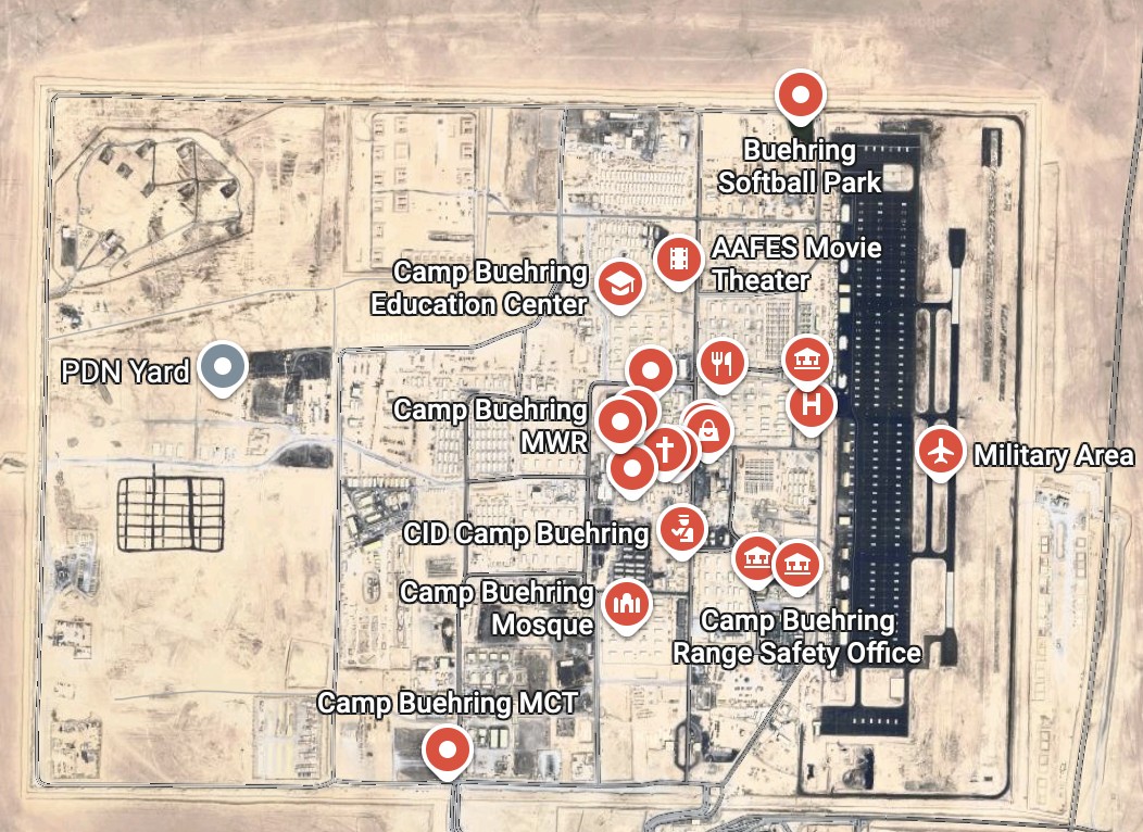
Bellingcat examined Camp Buehring and Camp Arifjan in Kuwait, Muwaffaq Salti Air Base in Jordan, and Al Udeid Air Base in Qatar. Google Maps labels facilities such as headquarters, gyms, accommodation and fuel points, while user photos, reviews and US military images provide additional detail. At Camp Buehring, researchers verified the locations of the main headquarters and a gym by matching maps with military photographs and satellite imagery showing the buildings after strikes. Gym reviews also indicated when the facility was busiest.
Experts said the public data could have supported Iranian targeting, but stressed that Iran had other intelligence sources, including Russian and commercial data. The bases were not secret, and governments can ask Google to blur or remove sensitive information. Bellingcat said the US Defense Department, CENTCOM and Google did not respond before publication.
Takeaways
- The investigation found that ordinary map labels, user reviews and military-published images can collectively reveal both facility locations and patterns of personnel activity.
- At Camp Buehring, Bellingcat matched a Google Maps headquarters marker and gym location with military photographs and post-strike satellite imagery.
Article timeline
Build this article’s timeline
Extract dated events, key actors, and open questions using the same timeline analysis available in Signal.
Log in to build
Timeline generation is available to signed-in community members.
Primary-source excerpts
Login to contribute excerpts from the source.
Five Ws
🤖 4 AI prefills · 1 still unanswered
Who
Joseph Jarnecki, CBS News, Bellingcat, and Royal United Services Institute
What
Bellingcat found that Google Maps and other public online sources expose detailed information about US military bases that may have helped Iran target them.
When
When did this happen, or what is the timeframe?
Where
Middle East, Iran, and Qatar
Why
Centers on Iranian missile and drone campaign, US military bases in the Middle East, and publicly available mapping platforms
Login to answer and earn XP for each gap you fill.
Open-Source Military Intelligence Google Maps, satellite imagery, public photographs, mapping platforms, facility labels Iranian Strikes on Bases Iran, missile campaign, drone attacks, US bases, military sites Targeting Vulnerabilities targeting decisions, intelligence, troop locations, personnel gatherings, operational security Base Damage Verification Camp Buehring, Camp Arifjan, Muwaffaq Salti, Al Udeid, headquarters
Key Phrases:
Iranian missile and drone campaign98% US military bases in the Middle East97% publicly available mapping platforms94% Google Maps facility information93% sensitive military base information91% Iranian targeting decisions90% commercially available location data88% satellite imagery87% Camp Buehring86% Camp Arifjan84%
People: Joseph Jarnecki
Organizations: CBS News2 Bellingcat8 Royal United Services Institute Reuters United States Department of Defense CENTCOM Google4 Defense Visual Information Distribution Service Tasnim2 IRIB News
29
Manipulation Score: Low
How much this article uses emotional framing vs. straight reporting
Loaded Language
2425%
Absolutist
415%
Threat/Panic
4225%
Us vs Them
1815%
Engagement Bait
3520%
Manipulation score look right?
Factual Claims (5)
medium
military
Bellingcat found that public mapping platforms expose detailed and potentially sensitive information about US military bases.
Bellingcat found that publicly available mapping platforms also reveal detailed and potentially sensitive information about US military bases in the Middle East.
high
military
Iranian strikes damaged at least 20 US military sites across seven Middle Eastern countries since February.
Iranian strikes have damaged at least 20 US military sites across Qatar, Bahrain, the United Arab Emirates (UAE), Jordan, Kuwait, Iraq and Saudi Arabia since the conflict began in February this year.
low
military
Bellingcat examined four US installations: Camp Buehring, Camp Arifjan, Muwaffaq Salti Air Base and Al Udeid Air Base.
We examined four of the largest and most heavily affected US military installations by Iran’s missile and drone campaign: Camp Buehring and Camp Arifjan in Kuwait, Muwaffaq Salti Air Base in Jordan an
low
technology
Google Maps labels facilities such as headquarters, accommodation, gyms and fuel points, while public images provide additional operational detail.
Google Maps and other online mapping services contain dozens of labels identifying facilities including headquarters, accommodation, gyms and fuel points.
medium
military
Experts said public data could have informed Iranian targeting, while Iran also had access to other intelligence sources.
Experts told Bellingcat that such information could have helped inform Iranian targeting decisions... Iran would also have had access to other sources of intelligence.
Comments
Login to view and post comments.